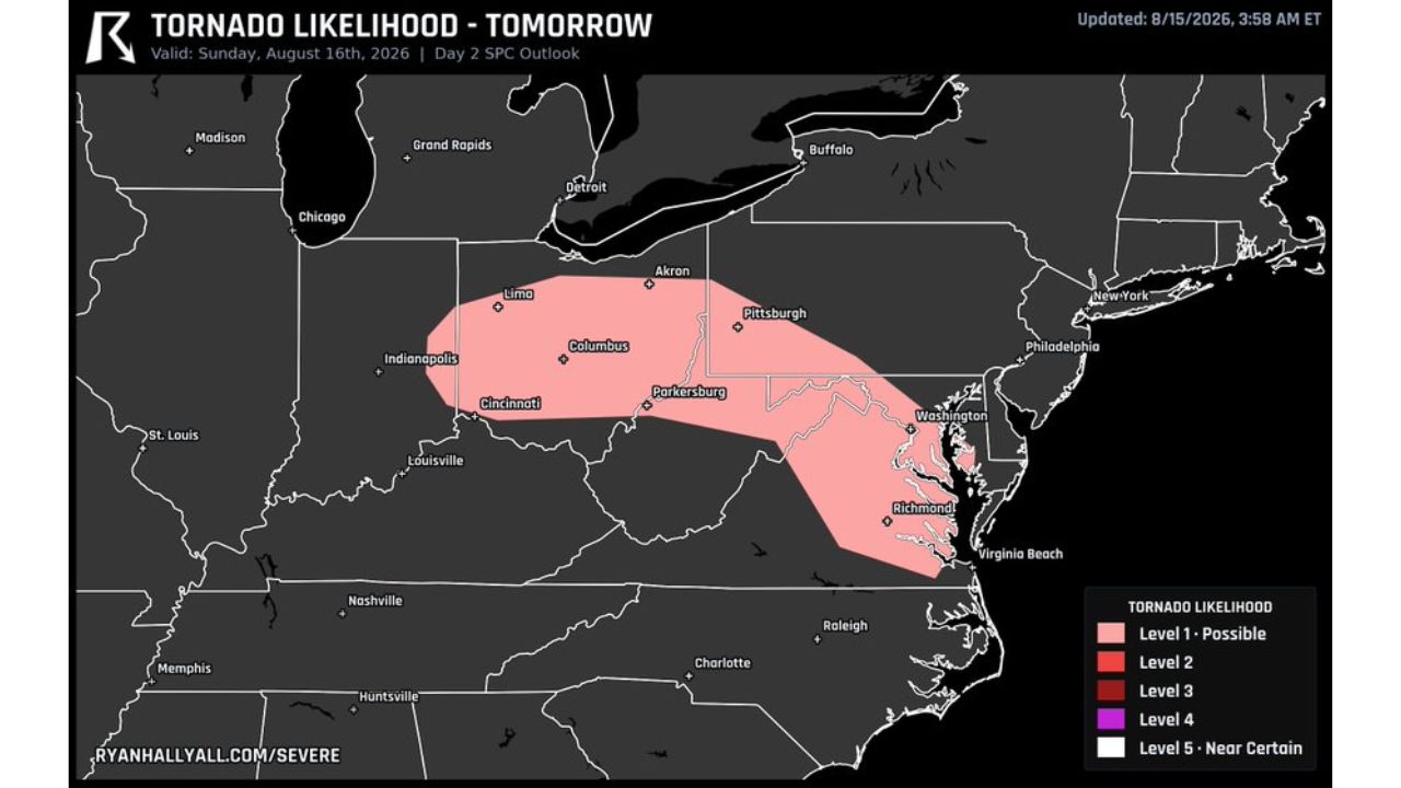
COLUMBUS, Ohio — A Level 1, “Possible” tornado likelihood zone stretches across a wide corridor Sunday, Aug. 16, running from Indianapolis and Lima through Columbus, Cincinnati and Parkersburg, then southeast into Washington, D.C., Richmond and Virginia Beach. The Storm Prediction Center’s Day 2 outlook, updated early Saturday, places tornado potential at the lowest tier on its five-level scale, but stretches that low-end risk across parts of five states and the nation’s capital.
What Sunday’s Outlook Shows
- Risk level: Level 1, “Possible” (lowest of five tiers)
- Valid: Sunday, Aug. 16, 2026
- Updated: 3:58 a.m. ET, Aug. 15, 2026
- Western edge of the zone: Indianapolis, Lima
- Central corridor: Columbus, Cincinnati, Parkersburg
- Northern edge: Akron, Pittsburgh
- Southeastern edge: Washington, D.C., Richmond, Virginia Beach
Why “Possible” Sits at the Bottom of the Scale
A Level 1 designation means forecasters see tornadoes as possible rather than probable or likely, the entry point on a scale that climbs through Levels 2 and 3 before reaching Level 4 and the rare Level 5, “Near Certain.” At this stage, two days out, the outlook is meant to flag early awareness rather than pinpoint exact timing or specific storm tracks, giving residents across the corridor, from the Ohio Valley to Chesapeake Bay, a heads-up to watch for updates as Sunday approaches.
What to Watch For as Sunday Approaches
As of this writing, this is a Day 2 outlook, issued a full day ahead of the risk window, so no watches or warnings tied to it have been issued yet. The zone is large and the risk level is the lowest on the scale, meaning conditions could sharpen, shift, or fade entirely as Sunday gets closer. This article will be updated as the picture becomes clearer.
Anyone in the corridor, particularly around Columbus, Cincinnati, Washington and Richmond, should keep an eye on forecast updates through Saturday night and into Sunday morning, since Day 2 outlooks like this one often get refined significantly once the event draws nearer.
For more coverage like this, check back for the latest severe weather updates.